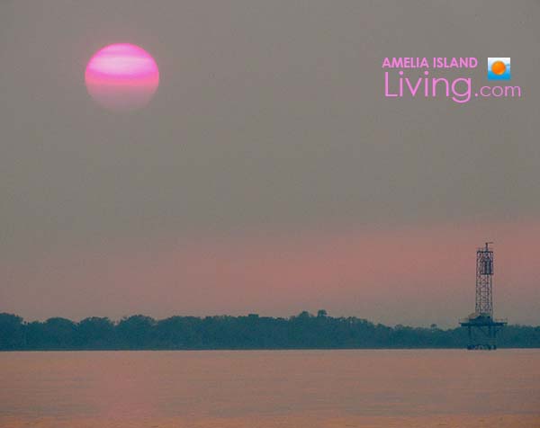
Smokey Haze, Fernandina's Amelia River, Pinkish Sunset 4-25-17
A lack of rain has created a dry southern landscape, a condition when lightning strikes can readily spark fires, as has been the case during Spring 2017 in the Sunshine State and nearby in southeast Georgia.
May 6, 2017 Smoke Blowing Southeast From West Mims Wildfire
*** UPDATE 6/25/2017: Fire officially out! A weather pattern that brought a few weeks with periods of heavy rain helped douse what had been the biggest wildfire in the USA (152,515 acres), near the GA-FL-border. ***
UPDATE 6/11/2017: Thankfully, the West Mims Fire at FL-GA border is now 85% contained.
UPDATE 5/6/2017: The largest, uncontained (only 12%) wildfire burning in the United States is located roughly 50 to 60 miles northwest of the Jacksonville Metropolitan Area. Sparked by lightning a month ago, the West Mims wildfire has burned 135,391 acres (54,791 hectares) around southeast Georgia’s Okefenokee National Wildlife Refuge, with over 500 personnel assigned to the incident. Criticallylow humidity and high winds gusting 25-35 mph on May 6th have fed the fire, said to be the worst weather conditions since it began. A massive smoke plume carried by the winds in a southeasterly direction on May 6, 2017 has created smoky conditions and reports of ash falling from the sky in Jacksonville, Florida. Driving west over the intracoastal on the Thomas J. Shave Bridge departing Amelia Island this afternoon, the bridge elevation provided a view of smoke seen in the distance to the west. An official smoke alert was issued around 2 pm stating “heavy smoke will impact an area from Jacksonville on the south to Yulee on the north.”
Florida State of Emergency Declared
It’s been an active spring 2017 wildfire season across the state in Florida. Wildfires are burning around the penninsula (see map below). On April 11, 2017, Florida’s Governor, Rick Scott, declared a state of emergency. Local governments, such as here in Nassau County, keep extending burn bans for property owners.
According to the Governor’s news release, “Executive Order 17-120 declared a state of emergency in Florida following the recent wildfires across the state and the high potential for increased wildfires to continue this year. Forecasts predict hotter and drier conditions than normal in Florida during the coming months. Florida wildfires have already burned 250 percent more acreage during the first three months of 2017 than during the same time period last year.”
At this time, central Florida has the highest concentration of fires and the worst drought conditons in the state. According to an Orlando Sentinel article, the city experienced the “second-driest March since records began in 1892.”
It doesn’t help that Florida is hit with the most lightning in America. According to research complied from 2005-2014, Florida leads the US in lightning strikes, with average “flashes per year of 1,203,854,” as measured by the National Lightning Detection Network.
More About West Mims Wildfire
Near the Florida-Georgia border, the huge West Mims wildfire, sparked by lightning, has been burning since April 6, 2017. As of April 29, 2017, the fire had encompassed a huge amount of land, around 96,000 acres, and morphed in size this past week. Thus far, the fire’s burned mainly within park land at the Okefenokee National Wildlife Refuge in Georgia and a bit across the border in Florida within the Osceola National Forest and John M. Bethea State Forest. The Okefenokee National Wildlife Refuge sprawls across three counties in Georgia — Charlton, Ware and Clinch — as well as extending into Florida’s Baker County.
Two windy April days when the breeze blew toward the east, a smoky haze reached Fernandina Beach on the Atlantic coast, about 50 miles away from the blaze. It made for some unusual hues to the sunset (pictured below, pink sunset photo taken on April 25, 2017). Light smoke was forecast to reach all the way to Atlanta on April 30, 2017, about 285 miles away from the fire site.
Smoky Haze, Fernandina’s Amelia River, Pinkish Sunset 4-25-17
Further unfortunate news is the long life expectancy of this wildfire. According to officials, the West Mims fire “may keep burning for the next six months.” Needed to slow the fire is “persistent heavy rain from a tropical storm or winter rains,” according to reports. The Georgia Forestry Commission Type 2 Incident Management Team is managing the fire along with the U.S. Fish and Wildlife Service, Florida Forest Service, and U.S. Forest Service.
How To Help, Donations
The Salvation Army is one of the organizations involved in helping the personnel fighting the West Mims Fire. According to their news release, “To volunteer or donate needed items locally, Service Center Director Sears asks people to contact The Salvation Army of Camden County, Georgia at 912-882-2200. Items most needed are shelf-stable foods, snacks, water, soft drinks, single packaged eye drops and lip balm. The best way to help after a disaster is to make a financial donation. Monetary donations allow disaster responders to immediately meet the specific needs of disaster survivors as the situation continues to be assessed.”
Follow fire news with daily updates issued by Inciweb. Or sign up to receive West Mim fire eMail updates. The estimated containment date for West Mims, as listed on Inciweb as of May 6, 2017 is: “Wednesday, November 1st, 2017 approx.”
Nassau County Wildfires
Here in Nassau County, the largest fire this spring to date was in Bryceville, an incident that burned around 700 acres in March and caused damage to some homes and structures. The fire was started accidentially by a homeowner’s apparent negligence, burning items in his yard on a windy day (he faces criminal charges).
Closer to Fernandina, a wildfire burned about 40 acres March 31st off Barnwell Road behind Lowe’s on A1A in Yulee, sparked at the railroad tracks by a passing train. Luckily it was contained and burned mostly marsh grass, but the fire reportedly came within 50 feet of some homes.
Wildfire Smoke Behind Lowe’s, A1A in Yulee, 3/31/2017
Cumberland Island Wildfire
A small wildfire sparked by lightning April 6, 2017, called the Hawkins fire, burned 7 acres in the wilderness area on Amelia Island’s next door neighbor, Cumberland Island, GA. The National Park Service took a “hands off” approach, allowing the fire to burn naturally. According to the National Park Service, “Fire is an essential, natural process,” said Superintendent Gary Ingram, “that the island ecosystems rely on for rejuvenation, reproduction, and survival.”
“Fighting Fire With Fire”
Park lands around the US often schedule controlled fires, i.e. “prescribed burns.” Okefenokee, the main site of the West Mims fire, has conducted prescribed burns in the past and planned some for 2017. A news release issued January 17, 2017 stated “Okefenokee National Wildlife Refuge plans to conduct prescribed burn projects over the next several months. These prescribed burns are used to restore longleaf pine habitat, reduce potential threat of wildfires, and increase plant and animal diversity.”
Prescribed burns are a planning tool utilized to remove excess accumulation of forest fuels (i.e. above ground plant material such as surface grasses, shrubs, branches, twigs, small or dead trees, etc.).
Fire management teams strategically use controlled burns to reduce overall risk of wildfires starting in the first place. But when they do, make wildfires more manageable. Learn more about prescribed burns at GoodFires.org.