Big Waves As Isaias Passed by Amelia Island Aug. 3, 2020
Atlantic Basin Tropical Cyclone Update
NOAA 2020 Atlantic Hurricane Season Outlook
NOAA issued a press release August 6, 2020, announcing its annual August update for their Atlantic Hurricane Season Outlook, illustrated above.
Atmospheric and oceanic conditions are primed to fuel storm development in the Atlantic, leading to what could be an “extremely active” season, according to forecasters with NOAA’s Climate Prediction Center, a division of the National Weather Service.
The 2020 Atlantic hurricane season has been off to a rapid pace with a record-setting nine named storms so far and has the potential to be one of the busiest on record. Historically, only two named storms form on average by early August, and the ninth named storm typically does not form until October 4.
7 To 11 Hurricanes Predicted
The updated outlook calls for 19-25 named storms (winds of 39 mph or greater), of which 7-11 will become hurricanes (winds of 74 mph or greater), including 3-6 major hurricanes (winds of 111 mph or greater). This update covers the entire six-month hurricane season, which ends Nov. 30, and includes the nine named storms to date.
Heed Guidance From Local Officials
“It is now more important than ever to stay informed with our forecasts, have a preparedness plan, and heed guidance from local emergency management officials,” stated NOAA in the press release.
Run Out Of Names?
If the new projections materialize (possibly up to 25 named storms), this year’s list of tropical cyclone names will not be enough. So what then, after “Wilfred” gets crossed off the list (storm name #21)? If need be, any further storms will go to the Greek alphabet. Storm #22 will be “Alpha,” storm #23 will be “Beta,” and storm # 24 will be “Gamma.”
2020 Atlantic Tropical Cyclone Names
What Is An Average Hurricane Season?
An average season produces 12 named storms, including six hurricanes of which three become major hurricanes (Category 3, 4, or 5).
“This is one of the most active seasonal forecasts that NOAA has produced in its 22-year history of hurricane outlooks, said U.S. Secretary of Commerce Wilbur Ross. “We encourage all Americans to do their part by getting prepared, remaining vigilant, and being ready to take action when necessary.”
Activity Vs. Landfall
It is important to note the difference between activity vs. landfall. According to NOAA, their hurricane season outlook “is for overall seasonal activity and is not a landfall forecast. Landfalls are largely determined by short-term weather patterns, which are only predictable within about a week of a storm potentially reaching a coastline.”
Amelia Island CAT 1 Evacuation Zone
In the event that a Category 1 hurricane is forecast to potentially be near northeast Florida, there will be a mandatory evacuation of Amelia Island(all of the island is evacuation zone A). This northeast Florida barrier island has experienced three mandatory evacuations during the past four hurricane seasons, triggered by Matthew (2016), Irma (2017), and Dorian (2019).
Hurricane Strength Categories 1 to 5
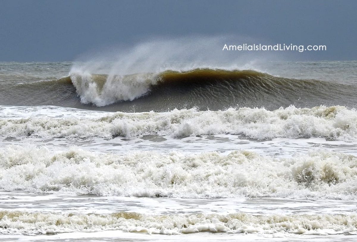
Isaias — August 3, 2020
The most recent storm, Isaias, stayed off the Amelia Island coastline about 100 miles out to sea as it passed by August 3, 2020. Nassau County Emergency Management had anticipated Nor’easter storm-like conditions here. We experienced balmy and breezy weather with some rough surf and rip currents. Most of the heavy rain bands seemingly missed the island.
Aug. 3, 2020– The Day Isaias Passed By Amelia Island
Amelia Island Surfer Waits For Waves, Isaias 8/3/20
Amelia Island surfers enjoyed bigger than normal waves along the shoreline. One surfer exiting the ocean said he’d been carried three miles along the shoreline from where he parked his car.
The ocean did wash away 13 sea turtle nests that had not yet emerged on the beachfront, according to Amelia Island Sea Turtle Watch nesting data. After passing by the Florida-Georgia border, Isaias strengthened to a Category 1 hurricane and made landfall in North Carolina Monday night, August 3, 2020.
Beware Potential Storm Surge
There’s a saying about hurricanes, “run from water, hide from wind.” This emphasizes the biggest concern — the storm surge and associated threat of drowning.
Nassau County Emergency Management held a hurricane round table streamed live on NASSAU EM’s Facebook page August 7, 2020. Comments made about storm surge were particularly interesting.
During the session, one of the panelists, Al Sandrik (Warning Coordination Meteorologist for the National Weather Service in Jacksonville), stated: “We reside in one of the most dangerous storm surge areas on the Eastern Seaboard of the United States.” He also indicated “we’re at the bottom of a bowl here at the Florida-Georgia border.”
“Few Inches To Over 25 Feet”
According to Nassau County’s website, “Depending on the scenario (i.e. Storm Category, Forward Speed, Direction, Ground Saturation), water depths all over the county could reach from a few inches to over 25 feet; surge can cause flooding well into our river basins, not just at the coast.”
Watch this NOAA “Ocean Today” video to learn more about storm surge.
A frequently asked question when a storm approaches is about the status of Amelia Island’s bridges. This topic came up during the NASSAU EM hurricane round table. The director of Nassau County Emergency Management, Greg Foster, explained how they use a wind meter and take intermittent measurements from the bridges.
When the wind is sustained at 39/40 MPH, Amelia Island bridges will be closed. Follow-up measurements will continue and NASSAU EM will decide whether and when to reopen the bridges. News updates during storms will be posted to social media to keep the public informed in an emergency. Follow updates via NASSAU EM on Facebook or on Twitter @NassauEm .